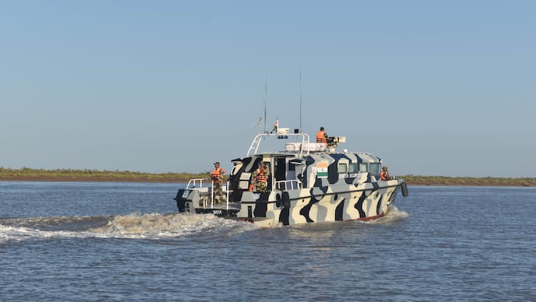
Defence Minister Rajnath Singh on Thursday delivered a sharp warning to Pakistan over its activities near the Sir Creek region, cautioning that any provocation would be met with a response so decisive it could “change both history and geography.” Speaking in Bhuj, Gujarat, during the Dussehra and Shastra Pujan celebrations, Singh accused Pakistan of deliberately keeping the Sir Creek dispute alive, despite India’s consistent efforts to find a peaceful resolution through dialogue.
“India has made several attempts to resolve the issue, but Pakistan’s intentions remain questionable,” Singh said. “The way Pakistan has expanded its military infrastructure in areas adjoining Sir Creek exposes these intentions. They must remember that in 1965, the Indian Army marched to Lahore. Today, one of the routes to Karachi also passes through this creek.”
#WATCH | Kachchh, Gujarat: Defence Minister Rajnath Singh says, “Even after 78 years of independence, a dispute over the border in the Sir Creek area is being stirred up. India has made several attempts to resolve it through dialogue, but there is a flaw in Pakistan’s intentions;… pic.twitter.com/aCRdorcb9A
— ANI (@ANI) October 2, 2025
His statement, delivered in a border state that has seen multiple security challenges in the past, underscores India’s growing unease at Pakistan’s recent military build-up in the strategically sensitive marshlands.
Why Sir Creek Is Back in the Spotlight
At first glance, Sir Creek looks like a remote, lifeless stretch of muddy estuary tucked away in the Rann of Kutch. Stretching 96 kilometres along the India-Pakistan border, this tidal creek separates Gujarat’s Kutch region from Pakistan’s Sindh province before emptying into the Arabian Sea.
But what seems like a desolate marshland holds tremendous importance. The dispute over Sir Creek determines not just where the land border lies, but also how the maritime boundary is drawn into the Arabian Sea. This directly impacts control over resource-rich waters, fishing rights, and Exclusive Economic Zones (EEZs) that extend deep into the sea.
For India and Pakistan, both heavily dependent on fisheries and energy imports, Sir Creek has major strategic, economic, and ecological stakes. The region is believed to hold oil and gas reserves, and it remains one of Asia’s richest fishing grounds. Thousands of fishermen on both sides depend on its waters for their livelihood. Ecologically, the marshlands host migratory birds such as flamingoes during winter, making it an important zone for biodiversity.
The Origins of the Dispute
The Sir Creek dispute is more than a century old, with its roots in colonial-era agreements. In 1908, disagreements arose between the ruler of Kutch and the Sindh government (then under the Bombay Presidency) over firewood collection in the area. To resolve this, the Bombay Government Resolution of 1914 was issued.
But the resolution itself contained contradictions.
- Pakistan’s Position: Islamabad relies on Paragraph 9 of the 1914 resolution, which places the boundary along the eastern bank of Sir Creek, effectively giving the entire creek to Pakistan.
- India’s Position: New Delhi cites Paragraph 10, which applies the thalweg principle. This principle in international law states that the boundary in a waterway should follow the mid-channel of the navigable portion. India maintains that Sir Creek is indeed navigable at high tide and is used by fishing vessels. Supporting evidence includes a 1925 map and boundary pillars built along the mid-channel in 1924.
Pakistan rejects the thalweg argument, claiming that tidal estuaries like Sir Creek do not qualify. This legal and cartographic tug-of-war has kept the dispute alive for decades.
Attempts to Resolve the Issue
Over the years, both sides have tried, and failed, to put the matter to rest.
- After the 1965 India-Pakistan war, British Prime Minister Harold Wilson’s mediation led to a tribunal in 1968. While the tribunal resolved much of the Rann of Kutch boundary, it left Sir Creek undecided.
- In 1997, the Sir Creek issue resurfaced in the Indo-Pak composite dialogue process.
- Between 2005 and 2007, joint surveys were conducted in the hope of finding common ground.
- In 1999, however, tensions spiked when an Indian fighter aircraft shot down a Pakistani surveillance plane over the creek.
Despite these efforts, a final settlement has never materialized, largely because neither side is willing to concede ground.
Escalating Military Posture
In recent years, Pakistan has significantly bolstered its military presence in the region. Since 2019, it has deployed additional Creek Battalions, marine assault crafts, coastal defence boats, radars, and even missile systems. Surveillance aircraft and air defence measures have also been strengthened.
India has responded in kind. The Border Security Force (BSF) and Indian Navy maintain a heavy presence in the area, especially after the 2008 Mumbai terror attacks, which were launched from the Arabian Sea. Indian agencies have intercepted suspicious boats in Sir Creek and, in 2019, abandoned vessels raised alarms about potential infiltration attempts.
This tit-for-tat militarization has transformed Sir Creek from a quiet, marshy waterway into a flashpoint with serious security implications. Pakistan also tried to attack this side during the clash in May but due to heavy air defence it was a total fail.
The Human and Economic Costs
Caught in the middle of this geopolitical tussle are local fishermen. With no clearly demarcated maritime boundary, fishing boats from both countries often drift into disputed waters. Each year, scores of Indian and Pakistani fishermen are arrested, jailed, and separated from their families. Although international conventions recommend leniency in such cases, both sides often use detained fishermen as bargaining chips, worsening humanitarian suffering.


